New FEMA map would add 200 square miles, 115K housing units to Harris County floodplains | Community Exchange
ArticleOur Environment
New FEMA map would add 200 square miles, 115K housing units to Harris County floodplains
A Kinder Institute analysis examines a proposed FEMA map that would add nearly 200 square miles and 175,000 housing units to Harris County floodplains.
Start with the plain guide. Open the deeper layers when you want the ecosystem around it.
IntensityNoticeRead, understand, orient.
StewardAgency
1Orgs
0Policies
18Links
First readWhat to know+
Topic: Proposed FEMA flood map adding 200 sq miles to Harris County floodplainsSource: Kinder Institute for Urban ResearchHomes Affected: About 175,000 housing unitsTimeline: Federal approval is at least 2 years awayBiggest Impact Areas: Northwest and northeast Harris County
Next rungHow to step in+
Good first step: Act Check if your address falls in a current or proposed floodplain
Visit msc.fema.gov and enter your address to see your flood zone status. Ask your city council member about the new proposed map.
Time and placeWhere this sits+
Our EnvironmentHIGH ORDER OF OWL TAILGATING SOCIETY
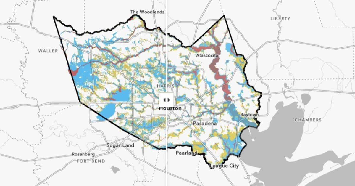
A new flood map proposed by the Federal Emergency Management Agency (FEMA) could bring nearly 200 more square miles of Harris County into official floodplains. Researchers at Rice University's Kinder Institute for Urban Research mapped out what that means for neighborhoods, homeowners, renters, and public buildings across Greater Houston. The map is not final — federal approval is still at least two years away — but understanding the potential changes now gives you time to prepare.
Under the current FEMA map, about 640 of Harris County's 1,777 square miles are already in a floodplain. The proposed update would add roughly 265 square miles and bring about 175,000 housing units into a floodplain for the first time. Around 60,000 units would be removed. At least 170 government buildings — including about 110 school campuses and 40 wastewater treatment plants — would gain a floodplain designation. The two highest-risk zones, the floodway and the 100-year floodplain, would see the most significant effects on insurance and building rules. The 500-year floodplain carries lighter requirements. FEMA last updated this map comprehensively in 2007.
Start by looking up your property's current and proposed flood zone status using FEMA's flood map tools. If you rent, ask your landlord or property manager whether the building may fall into a new zone. Homeowners and landlords in newly designated high-risk areas — especially the floodway or 100-year floodplain — should talk with an insurance agent about flood coverage options before any final map is approved. Local civic groups and county planning meetings are good places to weigh in during the public review period that comes before federal approval.
No fixed date
Not location-specific
This story connects to broader conversations about flood resilience, housing affordability, and infrastructure planning in Harris County. Communities near Cypress-area creeks and White Oak Bayou, northeast Harris County neighborhoods hit hard by Hurricane Harvey, Aldine, Pasadena, and the far western edges of the county all face notable changes. Areas like South Belt/Ellington and Alief may actually see flood zone relief. Public facilities like fire stations, wastewater plants, and schools are also affected, which ties into emergency preparedness and taxpayer costs for repairs and insurance.
If your home, rental, or nearby school lands inside a newly designated floodplain, your flood insurance requirements, property value, and local development rules could all change. Northwest and northeast Harris County face the biggest additions, including the Cypress area and communities near the San Jacinto River. Knowing your flood zone status early lets you plan ahead — financially and practically — before any rules take effect.